Maps are very important to help us learn about places. They show us where cities, rivers, mountains, and parks are located. Map of Nepal teach us about this interesting country’s land, people, and how it is organized. We can use Nepal’s maps to plan trips there one day!

Map Of Nepal
Maps are drawings that show where places are located. Maps provide an overhead or above view, similar to what you would see if you were a bird flying in the sky looking down! Map of Nepal helps us understand where key features of the land are, like its tall mountains, hills, plains, and river systems. Maps also show us where Nepal’s forests, nature reserves, villages, highways, and famous sites or landmarks are.

Some maps are physical maps and mainly show physical or natural features of the land, like mountains, bodies of water, and national parks. Other maps focus more on showing where people live, which are called political maps. Some maps aim to display both the natural and human-made features of Nepal. All maps of Nepal serve the important role of improving our understanding of the country.
Map Of Nepal With Districts
Nepal divided its land into smaller sections called districts to help organize the country and manage local areas. On maps, unique lines show the borders between each district. There are a total of 77 districts in Nepal.

Having a map that shows Nepal’s different districts provides insight into the country’s local governing or leadership structure. The borders help us differentiate one district from another and understand the overall division of Nepal’s land. District maps also showcase major cities and towns found within each district, further enhancing our understanding of governance and population distribution across Nepal.
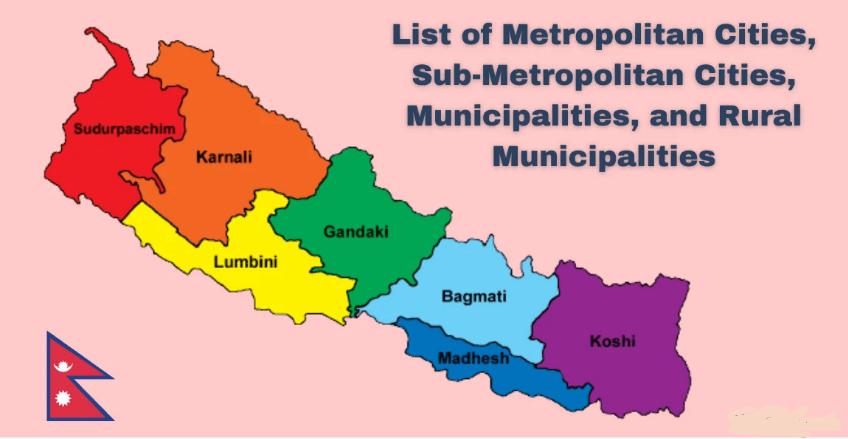
Map Of Nepal With Provinces
A few years ago, Nepal went through big government changes and reorganized its districts into 7 total provinces. Wide borders on maps now separate Nepal’s 7 provinces, which each contain a group of districts inside.

Looking at a map showing Nepal’s new provinces is important to appreciate the country’s political system and administration. The provincial borders help illustrate that there are now essentially 7 mini-governments inside Nepal, which exist under the federal or national government. The provinces have power and responsibilities over the districts they include. Maps provide clarity on this structure.
Political And Administrative Map Of Nepal
Political And Administrative Map of Nepal provides a comprehensive overview of the country’s territorial divisions, administrative structure, and major transportation infrastructure. It serves as a valuable tool for understanding Nepal’s political landscape, geographical features, and connectivity.

The map clearly delineates Nepal’s borders with its neighboring countries, India and China, highlighting the country’s strategic position in the South Asian region. It also depicts Nepal’s internal administrative divisions, including the seven provinces and 77 districts, providing insights into the country’s decentralized governance system.
Furthermore, the map illustrates Nepal’s major transportation networks, including its highways, national roads, district roads, and railways. This information is crucial for planning travel routes and understanding the country’s infrastructure development.
Overall, the Political And Administrative Map of Nepal serves as an essential resource for anyone seeking to gain a deeper understanding of the country’s political structure, geographical organization, and transportation infrastructure. It plays a significant role in facilitating informed decision-making, research, and travel planning.
Importance Of Maps In Nepal
There are many reasons why maps are valuable in Nepal. Here are some examples:
- Tourism: Nepal’s landscapes, culture, and landmarks attract visitors locally and globally. Maps help tourists navigate to popular sites like Mount Everest Base Camp, Kathmandu’s temples, Chitwan National Park, and more. Maps aid travel planning and exploration within Nepal.
- Transportation: Mapping out roads, highways, airports, and potential rail lines supports domestic transportation development in Nepal. Maps help assess infrastructure needs and expansions.
- Disaster Management: Being able to quickly pinpoint regions impacted by earthquakes, floods, or landslides through maps is crucial for organizing disaster relief in Nepal. Up-to-date maps save response teams time and facilitate rebuilding initiatives.
- Development Projects: Mapping villages, terrain types, and natural resources guide decisions on new infrastructure locations. Considerations include placing hydroelectric dams, bridges, hospitals, and telecommunication towers in suitable areas. Maps inform smart development and construction.
- Research: Scientists studying Nepal’s ecology, geology, weather, biodiversity, or even social trends rely on quality maps showing environmental factors, demographics, and statistics by location. Maps are foundations for research.
- Education: From school textbooks and projects to university courses, maps enhance learning about Nepal for all ages. Maps make grasping complex geography and political concepts about Nepal easier through visuals.


Leave a comment